
Security of land tenure is directly linked to poverty reduction, economic growth, improved resilience, environmental sustainability, and social stability. In Tanzania, less than 20 percent of land is surveyed, with about 1 million parcels registered with corresponding certificates of rights of occupancy (CROs) and certificates of customary rights of occupancy (CCROs) issued according to the Tanzania Five Year Development Plan 2016/2017-2020/2021.
However, a recent 33 country survey on perceptions of tenure security discovered that a quarter of the population feel their lands are insecure -- with significant likelihood of losing their rights over land. But land registration is a driver in tackling these challenges by legally recognizing and recording property rights.
I recently had the opportunity to present promising new technology to professional surveyors, professors and students in Tanzania. The modern and low-cost technology can help us to accelerate land registration more quickly and cheaply at the local level. Surveying is the first step in land registration and is needed to capture the size and boundaries of a land parcel. The amount of work and the cost is mostly determined by surveying method, accuracy, and availability of geodetic control points. In order to carry out traditional cadastral surveys – comprehensive land recordings- in urban areas, a high level of accuracy is needed, which is why expensive global navigation satellite system (GNSS) equipment is used. In African countries, it is common practice to follow the conventional survey method according to the old Surveys Act. However, this is costly, slow, and complicated, and has contributed to a low rate of registration across the region.

So how do recent technological advances in GNSS instruments and mobile applications provide more solutions to these challenges facing surveyor communities and governments for land registration?
In Tanzania, it is not easy for a small company or an individual cadastral surveyor to purchase their own surveying equipment due to its price which is usually more than hundred times their monthly income. Multiple and cumbersome procedures for cadastral surveying are also a stumbling block in accelerating progress in land registration for many countries. More importantly, not having enough opportunity to experience innovative technologies hinders everyone in changing their fixed mindset because... seeing is believing!
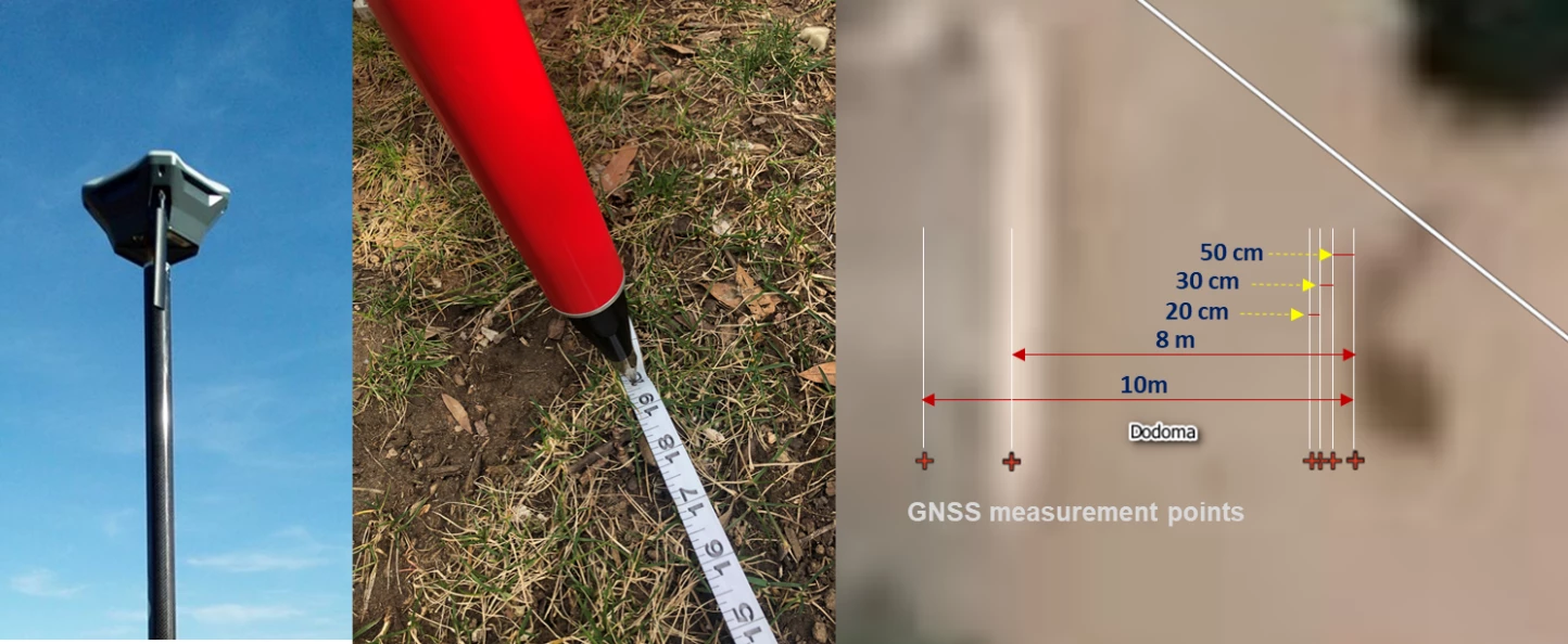
So on a recent trip to Tanzania where the land sector is one of key variables for unlocking the potential for economic growth by making land accessible and boost productivity, I brought some modern and low cost GNSS equipment to demonstrate how affordable technology can help to scale up land registration whilst maintaining survey-grade accuracy. My aim, to show how quickly we can use low cost equipment in conducting surveys and collect geospatial data in the field through streamlined procedures of positioning techniques. We worked with the Ministry of Lands, Housing and Human Settlements Development (MLHSSD) to prepare the demonstration. The Surveys and Mapping Division (SMD) of MLHSSD in Tanzania hosted a technical workshop in Dodoma inviting more than 30 private licensed surveyors to showcase modern and fit-for-purpose technologies along with international good practices. The SMD issued a difficult challenge of measuring 50cm, 30cm and 20cm distance using GNSS equipment with satellite signals, a task which is hard to achieve even with expensive GNSS equipment without proper measurement.
Most of smartphones and civilian navigation devices have five to ten-meter range accuracy because satellite signals transmitting location data contain a variety of errors (e.g. multipath error, signal-in-space ranging error, residual ionospheric and troposphere error, horizontal DOP, etc.) and that is a reason it is challenging. Therefore, the sophisticated positioning techniques are required to refine and correct the raw satellite signals for survey-grade data capture. The low cost GNSS can reach sub-half meter accuracy generally, but during the field test, it perfectly measured 1m, 50cm, and even 20cm in just in 5 minutes! even while not connecting to the national geodetic control network.
Professional surveyors were amazed with the results (as was I) and all initial doubts were put to rest by the performance of the modern GNSS equipment – which cost less and streamlined procedures by reducing measurement time.
Following the demonstration in Dodoma, I held a second demonstration with the School of Earth Sciences, Real Estates, Business and Informatics at Ardhi University –which specializes in land and architectural studies in Dar es Salaam. It was an excellent opportunity to share the modern and affordable technologies with more people. They too witnessed the promising possibility of changes as a first step of adapting modern technologies.
The positive initiative through technical support and innovation in land registration will encourage the developing world to democratize land surveying by reducing entry barriers, empowering even more local human resource, and weakening profession monopolies. The modern and fit-for-purpose technologies will be a driver to scale up the issuance of land certificates in urban and rural areas in Tanzania.
Related:
- Subscribe to our Sustainable Communities newsletter
- Follow @WBG_Cities on Twitter

Join the Conversation